

The good news for people across the Northeast is that the plume of wildfire smoke that made the air so difficult to breathe in the last week has largely dispersed, for now.
The bad news is that in its place on Tuesday will be yet another run of severe storms that could bring torrential downpours of rain, flash flooding, powerful winds, large hail and even a possible tornado to areas that are still reeling from similar storms over the weekend.
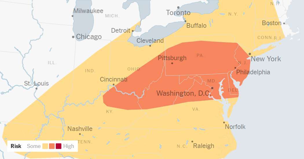
The Storm Prediction Center, an arm of the National Weather Service, warned that tens of millions of people from Kentucky to New York were facing a risk of severe thunderstorms on Tuesday. In many places, forecasters said, the greatest threat is likely to come from damaging wind gusts — some potentially as strong as a hurricane’s.
Philadelphia, Baltimore, Pittsburgh and Washington are all in the bull’s-eye of an area that is likely to experience the most severe weather on Tuesday. New York, Cleveland and Nashville are in the next ring out, where the forecast still has meteorologists concerned, but the risk is slightly lower.
Though some storms are expected early in the day, forecasters across the Northeast warned that the most severe weather was likely to arrive in the afternoon and evening.
In Pennsylvania, the State College office of the Weather Service warned that Tuesday’s storms could reach a level of intensity to which only one or two systems rise each year. In Washington, forecasters warned late Monday that the ingredients were building for a “significant” severe weather situation to unfold on Tuesday.
Heavy rainfall is also expected to become a significant concern on Tuesday. Although the storms are forecast to move through the Mid-Atlantic and Northeast relatively quickly, forecasters said that repeated rounds of storms could pass over the same areas, producing high rainfall amounts that could lead to flash flooding.
In New York City, the storms are expected in two rounds: one between 9 a.m. and 2 p.m., and another, more severe, from 6 p.m. to 11 p.m. The Weather Service office in New York warned that up to two inches of rain per hour could fall — easily enough to lead to flash flooding in urban areas. A flood watch was in effect for New York City and southeast Pennsylvania through to northern New Jersey through late Tuesday night. Flood watches were also in effect for areas of Kentucky, southern Ohio, western Pennsylvania and West Virginia.
“While no two events are the same, the setup tomorrow is similar to what we saw last Saturday,” forecasters at the New York office of the Weather Service wrote late Monday night. In the New York area on Saturday, potent storms dropped huge amounts of rain over just a few hours, leading to flash flooding across the region. More than three inches of rain was recorded in Jersey City and Manhattan, and one weather station near Newark recorded four and a half inches of rain.
Videos shared on social media showed people caught driving in floodwaters, including a box truck that became partially submerged under a Brooklyn-Queens Expressway overpass.
